Point Clouds: Simplify transfer from Point A to Point B
AEC project teams are using point cloud data to enhance their BIM projects. By importing point cloud data into their CAD software, they can get a more accurate representation of the buildings and landscapes they are working on. This can help with design, construction, and even marketing efforts.
What is Point Cloud Data?
Point cloud data is a collection of data points used to create a three-dimensional representation of an object or surface. This data can be collected using a variety of methods, such as laser scanning or photogrammetry.
How is Point Cloud Data Used in AEC?
Point cloud data is most often used to create as-built models of existing buildings or structures. The data creates more accurate models for renovation or demolition projects, and additionally, can be used to create virtual reality simulations for training or marketing purposes.
How Does Point Cloud Data Enhance BIM?
Point cloud data enhances BIM by providing a more accurate representation of an existing structure. This data can be used to create models that are more realistic and detailed than those made without point cloud data. Additionally, point cloud data can be used to develop clash detection simulations, which can help to avoid construction delays and errors.
What are the Benefits of Using Point Cloud Data?
Using point cloud data can help to avoid construction delays and errors, as well as save time and money through improved accuracy and enhanced BIM
What Are The Drawbacks to Using Point Cloud Data?
The cost of manually collecting and processing the data from the jobsite to office teams can hinder progress and jeopardize project milestones. In some cases, the jobsite may have internet connectivity, but the field teams may not have the specialized software to transfer the data in a timely manner.
Point clouds are extremely large files, often upwards of 2 GBs. Since most email systems prevent sending messages over 25MB, files cannot be transferred as email attachments. Some teams resort to uploading their files to cloud accounts such as Box or Dropbox as a workaround, but unfortunately, with internet connections at many sites being slow and unreliable, it is almost impossible to upload files successfully. Even when the internet connection is good, it can still take hours for the upload operation (drag and drop) to complete. Teams cannot sit around all day waiting for a file to upload, so they transfer the point cloud data to external hard drives and physically ship them to their project partners. This approach takes time and risks the data being damaged in transit.
How Egnyte Helps to Overcome Point Cloud Challenges?
Egnyte’s Smart Cache solution deployed with a small form factor device, like a Lenovo ThinkCentre or Dell Optiplex, enables field users to drag and drop point cloud data sets from external disk or SSD drives to the Egnyte drive letter. Smart Cache automatically uploads these files to the designated project folder in the Egnyte cloud.
If its not possible to deploy a form-factor device at the jobsite, you can install Egnyte’s Desktop App on a laptop and configure a cloud-connected folder on your laptop’s C drive. A field engineer can then drag and drop the point clouds from the external disk or SSD drive into the cloud-connected folder.
Both these operations outlined above occur within minutes, and the field engineer doesn’t have to contend with the delays related to internet speeds at the jobsite.
Let’s see how it works.
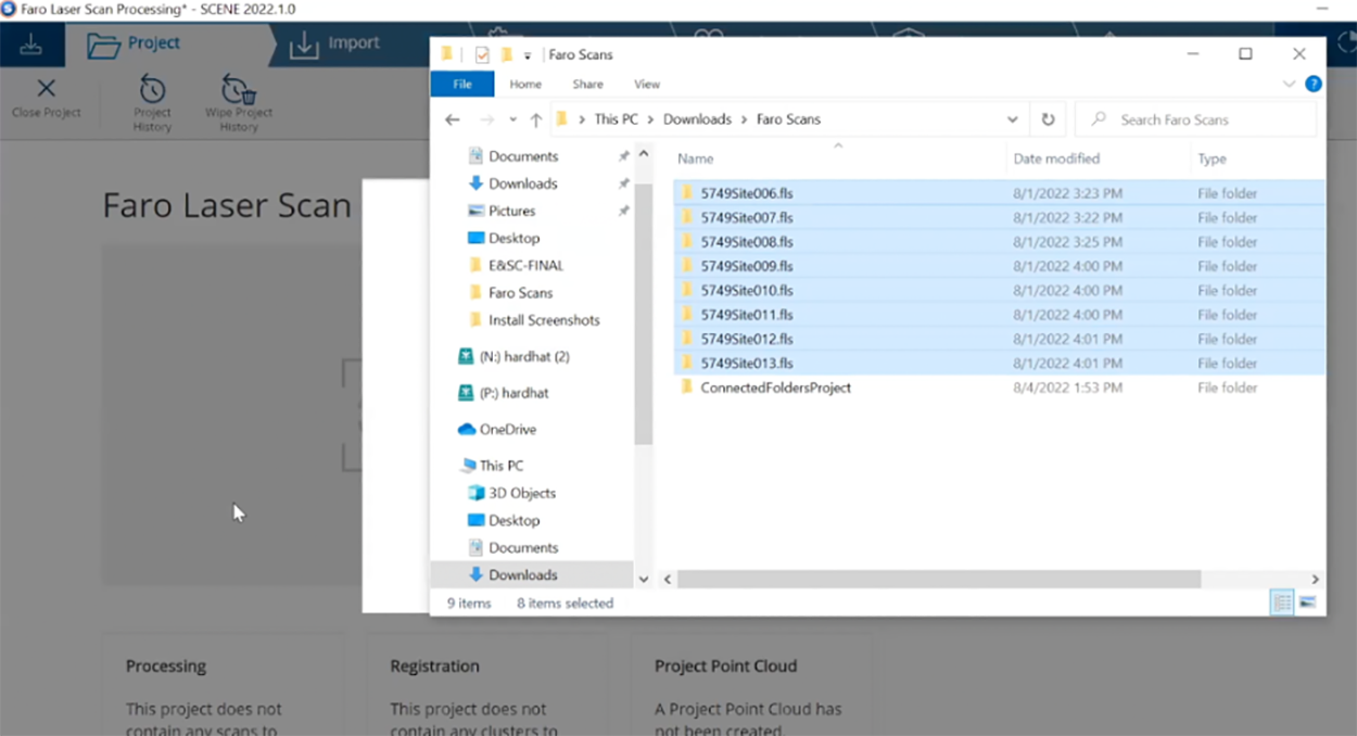
First, the user designates a folder within Egnyte Desktop App as a cloud-connected folder. In this example, I have designed the “Faro Scans” folder in my laptop’s Downloads as a cloud connected folder.

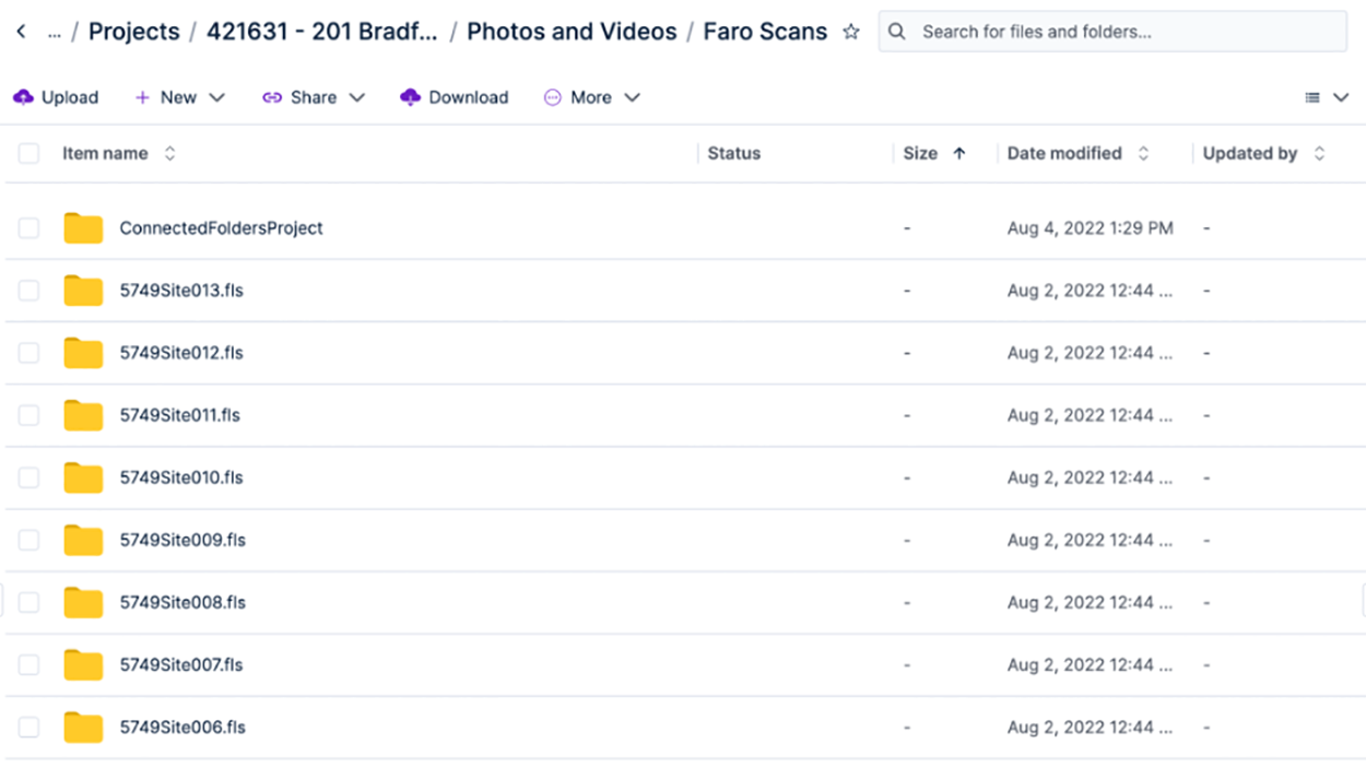
“Faro Scans' folder connects with /Shared/Projects/421631-201Bradford/Photos and Videos on Egnyte cloud.

Next, drag and drop the point cloud content from the external hard drive or SSD to the Connected Folder. In this example, I dragged and dropped my point scans into the Faro Scans folder on my laptop. Since the drag-and-drop operation is to your local disk, the point clouds get transferred at local disk speeds, taking minutes vs. hours.

Once the upload completes, Desktop App automatically transfers those files to the Project folder on Egnyte cloud. Desktop App has built-in resiliency to upload files even when you have network failures or internet outages. While the Desktop App uploads these point scans to the cloud, I can open Faro Scene on my workstation and import these point scans for registration and validation.
Point cloud data is transforming BIM projects by increasing the accuracy of as-built models of existing buildings. However, there are drawbacks, including the need for a stable, high-speed internet connection for large file transfers. Egnyte’s hybrid architecture, Smart Cache, overcomes these drawbacks by enabling uploads of large point cloud data sets to the cloud, making it readily available to anyone who needs the file regardless of connectivity constraints. This makes Egnyte an ideal solution for AEC firms that want to take advantage of the benefits of point clouds without having to worry about the drawbacks.


